Multispectral and Thermal
Msaada wa Multispectral
Tangu toleo 0.9.9 ODM lina msaada wa msingi kwa uchambuaji radiometric, ambayo inaweza kutengeneza tashira picha kutoka multispectral camera. Multispectral camera inapiga picha nyingi za sehemu kutumia band sensor tofauti.
Supported Sensors
Wakati tumedhamiria kusaidia camera nyingi iwezekanavyo, msaada wa multispectral umekuzwa kwa kutumia camera zifuatazo, kwa hiyo zitafanya kazi vizuri:
Sentera 6X (as of ODM version 1.0.1)
DJI Phantom 4 Multispectral (as of ODM version 2.8.8)
DJI Mavic 3 Multispectral (as of ODM version 3.5.3)
Kamera nyengine zinaweza kufanya kazi. Unaweza kutusaidia kuengeza idadi hii ` kugawa dataseti <https://community.opendronemap.org/c/datasets/10>`_ zilopigwa na kamera nyengine.
Creating Orthophotos from Multispectral Data
For supported sensors listed above (and likley other sensors), users can process multipsectral data in the same manner as visible light images. Images from all sensor bands should be processed at once (do not separate the bands into multiple folders). Users have the option to pass the --radiometric-calibration parameter with options camera or camera+sun to enable radiometric normalization. If the images are part of a multi-camera setup, the resulting orthophoto will have N bands, one for each camera (+ alpha).
NDVI and other vegetation indices can be calculated from these stitched orthophotos using software such as qGIS
Learn to edit and help improve this page!
Workflows for Non-supported Sensors
Sentera AGX710:
While the Sentera AGX710 is not officially supported by ODM, the following workflow gives some good results.
all JPGs from the NDRE directory should be renamed with the exact following pattern 0000X_NIR.jpg. No extra '_' should be present in the file names ie 10_51_14_IMG_00008.jpg => 00008_NIR.jpg
all JPGs from the nRGB directory should be renamed with the exact following pattern 0000X_RGB.jpg. No extra '_' should be present in the file names ie 10_51_14_IMG_00023.jpg => 00023_RGB.jpg
All renamed XXXX_NIR.jpg and XXXX_RGB.jpg should be placed in the same folder
The following command could be used to create an odm_orthophoto.tif file
docker run  --rm -v  input_image_dir/:/code/images \
-v output_dir/odm_georeferencing:/code/odm_georeferencing  \
-v output_dir/odm_orthophoto:/code/odm_orthophoto \
-v output_dir/odm_report:/code/odm_report \
opendronemap/odm --auto-boundary
After the successful ODM processing, odm_orthophoto.tif bands names could be accurately renamed using contrib/ndvi/rename_sentera_agx710_multispectral_tif.py script
python3 contrib/ndvi/rename_sentera_agx710_multispectral_tif.py output_dir/odm_orthophoto.tif
output_dir/odm_orthophoto.tif could be open with QGIS with correct band names
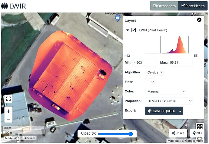
Thermal Support
ODM has support for radiometric calibration of thermal data, which is able to generate temperature orthophotos from long-wave infrared (LWIR) cameras. LWIR images can be processed alone or as part of a multispectral dataset.
Hardware
While we aim to support as many cameras as possible, thermal support has been developed using the following cameras, so they will work better:
Kamera nyengine zinaweza kufanya kazi. Unaweza kutusaidia kuengeza idadi hii ` kugawa dataseti <https://community.opendronemap.org/c/datasets/10>`_ zilopigwa na kamera nyengine.
Matumizi
Process the images using the --radiometric-calibration camera parameter to enable radiometric calibration.
Learn to edit and help improve this page!